
This is the reason I went from running a 3rd edition D&D game to running a Castles & Crusades / Swords & Wizardry hybrid. Less time spent on rules and number crunching, and more time to describe lost temples, majestic city-states and dank orc lairs.
When it came to designing my campaign world, I started off in the vein of classic Greyhawk. I drew a map of the continents, penciled in the national borders, threw in some settlements (thank you Medieval Demographics Made Easy), grabbed the coolest heraldry that I could find, and wound up with a nice little encyclopedia of facts and figures that never came into play once my player’s boots hit the ground. In short, I forgot that I was designing a game setting, and got caught up in the fun (for me) of designing a world. So, it was time to retool. Gone were the nation states and in came a few islands of human civilization surrounded by a vast, chaotic wilderness. Gone were the Encyclopedia Britannica maps and in came the hex maps. Gone was a vast world with dozens of regions, and in came a small, tightly focused … well, not so fast.
One of the things I like best about this planet we live on is the diversity. Paging through an atlas, you might see things like “United States of America” and “China”, but get beneath the surface of those black lines crisscrossing the globe and you’ll find thousands of unique cultures. The internet, especially sites like Google and Wikipedia make it possible for an average person to discover, on a daily basis, peoples, places and things of which I had never heard. When you consider how different many modern societies are from our own, the mind boggles at how different societies were a thousand years ago from our own. The world is incredibly rich, and with my love of exploring it, I was going to need way more than a single region for my fantasy campaign. Imagine the possibilities. If you’ve decided that a band of adventurers in something approximating medieval England need the quills of a manticore for whatever mystical nonsense they’ve involved themselves in, how cool is it that they have to travel half-way across the globe, to India, to get them. Because India is the only place on earth where manticores can be found. When I first let my players glimpse my partially completed atlas, there was an immediate interest in visiting the places on the map, places like Amazonia, the Klarkash Mountains and the Plains of the Emu Riders. That was the campaign I was going for; adventurers getting outside the bounds of stuffy civilization and seeing what was over the next hill, and knowing that Amazonia in Hybresail and the Forest Perilous in the Motherlands are going to be dramatically different places – different cultures, different sights and sounds and smells and different monsters. So, when it came to making my world, I simplified everything but the map. For the map, I went big.
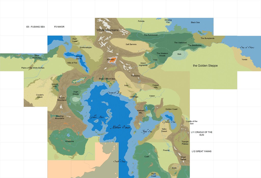
What you see here is the product of a ridiculous number of hours spent filling in hexes. Every square on that map represents a map measuring 75x45 hexes (give or take - the further north or south you go, the more those maps are stretched out). Initially, I used a free hex mapping software, and the finished regions on this map were done with that software. Recently, I bought the pro license for Hexographer, designed my own hex graphics, and began the process of re-drawing those regions.
Nod is arbitrarily divided into six “continents”. On the east coast of Mother Ocean are the Motherlands, my fantasy Europe. To the South is Lemuria, a mash-up of African in the north and India and Southeast Asia in the south. To the east of the Motherlands and Lemuria lies the Mu-Pan Empire, my fantasy China. North of that is Ultima Thule, the continent of prehistoric giant mammals and barbarians in fur swim-wear. On the west side of Mother Ocean we find Antilia in the north and Hybresail to the south. Beneath the surface of Nod are several underworld vaults inspired by pulp fiction, with the deepest vault holding something akin to Dante’s Hell. Beyond Nod there is Astral space and a Copernican system of planets to explore. And maybe someday, some adventurer will get all the way to the Firmament and try to drill through to whatever lies beyond.


No comments:
Post a Comment